Interwest GIS implemented the Operations Dashboard for the City of Elk Grove to display building permit data. Our team had been creating monthly pdf maps for the City's Building Department and felt the dashboard would be a meaningful way to display both an interactive map and graphs showing the number of residential and commercial permits per month.
A model was created to join the permit data to the parcel data to display in the map and graphs.
In addition to giving a snapshot overview of permit activity, the interactive map allows citizens and staff to click on area and get more information about the permit.
An Operations Dashboard is a great way to display graphs and maps to monitor activities such as building permits or maintenance requests. Need help implementing Operations Dashboard for ArcGIS? Contact Interwest GIS for more information.
Showing posts with label City of Elk Grove. Show all posts
Monday, June 5, 2017
Friday, November 11, 2016
Honoring our Heroes: Military Banner Program
The City of Elk Grove launched a Military Street Banner Program honoring veterans who reside in the City or resided in the City and are now deceased. The City designated 75 poles for the program.
Interwest GIS solved the following needs for the City:
Provide the contractor installing banners location information
Interwest created a web map of each banner's location to assist the contractor in installing the banners.
Provide City staff a way to track the installation date of each banner with workflow reminders
Each banner is installed for a 12 month period after which the banner is removed a new banner is printed and installed in its place. City staff needed a way to track the installation date of the banners with workflow reminders of when a banner needed to be removed so the staff could order the printing of a new banner and schedule the installation. Interwest's GIS Team created a SharePoint list that integrates with the GIS streetlight data to feed the installation map for the contractor and the public map.
The SharePoint list contains all streetlights. Each evening an SSIS package runs and imports the data from the SharePoint list into an SDE table. A spatial view is used in the map to join the table to the streetlights layer. A script is also run nightly to update the data in ArcGIS Online so the public map is up-to-date.
Provide the public a way to find the location of their veteran's banner
Until a custom banner has been purchased, banners honoring all veterans are displayed on the poles. A public web app was created to assist the public in searching for and locating their veterans banner. A story map was also created showing the veterans photo, name, branch, and rank.
Interwest GIS solved the following needs for the City:
Provide the contractor installing banners location information
Interwest created a web map of each banner's location to assist the contractor in installing the banners.
Provide City staff a way to track the installation date of each banner with workflow reminders
Each banner is installed for a 12 month period after which the banner is removed a new banner is printed and installed in its place. City staff needed a way to track the installation date of the banners with workflow reminders of when a banner needed to be removed so the staff could order the printing of a new banner and schedule the installation. Interwest's GIS Team created a SharePoint list that integrates with the GIS streetlight data to feed the installation map for the contractor and the public map.
The SharePoint list contains all streetlights. Each evening an SSIS package runs and imports the data from the SharePoint list into an SDE table. A spatial view is used in the map to join the table to the streetlights layer. A script is also run nightly to update the data in ArcGIS Online so the public map is up-to-date.
Provide the public a way to find the location of their veteran's banner
Until a custom banner has been purchased, banners honoring all veterans are displayed on the poles. A public web app was created to assist the public in searching for and locating their veterans banner. A story map was also created showing the veterans photo, name, branch, and rank.
Labels:
City of Elk Grove,
GIS,
Heros,
Military Banners,
Story Map,
Veterans
Thursday, November 10, 2016
Using GIS for Transit Analysis
Interwest provides GIS services to public agencies to analyze route changes and ridership. The City of Elk Grove is conducting a Comprehensive Transit Analysis that will be used to define the future of transit in the City.
Interwest GIS created an interactive web application using Esri's Web AppBuilder to show existing and proposed routes. As part of the analysis, the City's transit team developed a "service plan working paper" that included exhibits showing the recommended service improvements. This web app displays the information in an interactive form that allows the public and council members to review the proposals with more flexibility.
The web map also needed to display the relationship between routes and major employment centers, schools, and hospitals.
Interwest GIS worked with IBI, the City's Transit Consultant, to convert the proposed routes from Adobe Illustrator exhibits into a format that could be published to an ArcGIS Online web map. Special attention was placed on the zoom scale of the application to support the visual requirements of offsetting routes to display multiple features while ensuring it wasn't possible to zoom in far enough for the routes to appear not on the roadway.
Interwest GIS created an interactive web application using Esri's Web AppBuilder to show existing and proposed routes. As part of the analysis, the City's transit team developed a "service plan working paper" that included exhibits showing the recommended service improvements. This web app displays the information in an interactive form that allows the public and council members to review the proposals with more flexibility.
The web map also needed to display the relationship between routes and major employment centers, schools, and hospitals.
Interwest GIS worked with IBI, the City's Transit Consultant, to convert the proposed routes from Adobe Illustrator exhibits into a format that could be published to an ArcGIS Online web map. Special attention was placed on the zoom scale of the application to support the visual requirements of offsetting routes to display multiple features while ensuring it wasn't possible to zoom in far enough for the routes to appear not on the roadway.
Thursday, June 18, 2015
Sacramento GIS User Group Presentation: The Elk Grove Enterprise GIS Platform
Last month, Steve Gay gave a presentation at the Sacramento GIS User Group meeting featuring the City of Elk Grove's GIS Implementation. View the presentation here.
Thursday, May 7, 2015
Drought Response and Water Conservation with GIS
The City of Elk Grove's citizens are served by multiple water purveyors. Each agency is responsible for determining rationing and restrictions of its customers as California faces the most severe drought in recorded history. The City created a web page to help citizens determine which agency services their home and their home's permitted watering days and times.
Interwest's GIS team assisted this effort by creating a web map for citizens to determine which agency services their home.
In addition to the webmap, Interwest created a widget for the webpage that allows a citizen to look up their address and determine their watering restrictions. Addresses auto-fill as the citizen types, the citizen selects the appropriate address and searches.
The widget accesses the rest end point of the ArcGIS Online hosted feature service to display restrictions based on the water purveyor servicing that address and the even/odd address number of the parcel.
Interested in having Interwest's GIS Solutions team assist with your agency's drought response efforts? Contact the GIS Team to get started.
Interwest's GIS team assisted this effort by creating a web map for citizens to determine which agency services their home.
In addition to the webmap, Interwest created a widget for the webpage that allows a citizen to look up their address and determine their watering restrictions. Addresses auto-fill as the citizen types, the citizen selects the appropriate address and searches.
The widget accesses the rest end point of the ArcGIS Online hosted feature service to display restrictions based on the water purveyor servicing that address and the even/odd address number of the parcel.
Interested in having Interwest's GIS Solutions team assist with your agency's drought response efforts? Contact the GIS Team to get started.
Labels:
ArcGIS Online,
City of Elk Grove,
Drought,
smart community,
sustainable community,
Water Conservation
CSD Demonstrates Storm Water Compliance Using GIS
Cosumnes Community Services District (CSD) needed to create an inventory of drainage inlets to meet California State Water Control Board storm sewer system requirements.
Interwest acquired data, created map products, and a custom webpage to view and edit the data:
The data creation process included starting with the infrastructure provided by the City of Elk Grove, removing inlets, pipeline and outfalls that were not connected to CSD’s parks or firestation, adding new inlets that were within CSD’s properties, and mapping them to their appropriate outfall. Field inspections were conducted using Collector for ArcGIS to add inlets and their related details and photos.
The District is able to demonstrate the flow of storm water from inlet to outfall to the California State Water Control Board for each of their properties, track inspection date, watershed area, ownership information and images to assist with state requirements as well as maintenance efforts.
The webpage allows staff to edit live data from the rest end point of the hosted feature class; any changes to the inlets on the webpage are available immediately on the map in ArcGIS Online or Collector for ArcGIS.
Interwest acquired data, created map products, and a custom webpage to view and edit the data:
- Data exports acquired from the City of Elk Grove
- Web map of inlets, pipelines, and outfalls in or near the CSD’s parks and fire stations
- Field inspections to add inlets within the District’s parks
- Custom webpage to display the inlet details and images
The data creation process included starting with the infrastructure provided by the City of Elk Grove, removing inlets, pipeline and outfalls that were not connected to CSD’s parks or firestation, adding new inlets that were within CSD’s properties, and mapping them to their appropriate outfall. Field inspections were conducted using Collector for ArcGIS to add inlets and their related details and photos.
The webpage allows staff to edit live data from the rest end point of the hosted feature class; any changes to the inlets on the webpage are available immediately on the map in ArcGIS Online or Collector for ArcGIS.
Interested in having Interwest's GIS Solutions team assist with your agency's State Water Control Board requirements? Contact the GIS Team to get started.
Labels:
ArcGIS Online,
City of Elk Grove,
Collector,
Cosumnes Community Services District,
livable communities,
smart community
Monday, April 13, 2015
LED Retrofit Utilizes ArcGIS Platform
Interwest provides GIS services to local government agencies to assist in field collection and citizen communication. The goal of this project was to provide field collection tools for staff converting streetlights to LED and a communication tool to share the progress with citizens in the City of Elk Grove. The City was already using ArcGIS Online as a platform to collaborate with GIS and other data so this tool was the natural solution to support the LED retrofit.
FIELD INSPECTIONS
To ensure accurate cost estimates an inventory of all lights was conducted using Collector for ArcGIS. Missing lights were added, retired lights were removed and the description of light types was updated. This data was exported for inclusion in the Request For Proposals. Once the project was under way the installation contractor also utilized Collector to track the date each light was modified. The view of the data for field crews was limited to just the attributes they needed to modify.
COMMUNICATION
Project mangers were able to review the data for lights as they were replaced. They could inspect and accept each light as appropriate. A very streamlined webmap application was created to show the public the status of lights as they were completed.
KEY BENEFITS
Ease of use - Installation crews received one hour of introductory training. They modified GIS data for over 10,000 streetlights and did not request technical assistance at all throughout the process.
Up-to-the-minute data – Utilizing a platform that is accessible to all stakeholders allowed the data being captured in the field to be accessible to project mangers and citizens immediately.
Centrally tracked data eliminated the situation of data inconsistency that often occurs when multiple copies of data is stored.
A grid showing the scheduled dates for installation showed citizens when to expect work in their neighborhood. The exact installation status of each light displayed the specific progress on each street.
The billing process was very efficient enabling staff to authorize payment on exactly the lights that were installed – per the vendors field data entry.
Speed of system deployment - A sample version of the database was created and accessible to the field crews in less than a week.
Most changes that were requested during the project were able to be accomplished immediately with no disruption to the field crews workflow.
BEFORE & AFTER
Images available on the City's website.
Labels:
ArcGIS Online,
City of Elk Grove,
Collector,
LED Light Conversion,
livable communities,
smart community
Wednesday, December 10, 2014
Empowering Citizens' Emergency Preparedness with GIS
Interwest's GIS team created an interactive webmap to allow the citizens of Elk Grove to quickly locate the nearest open location to pick-up sandbags, enabling citizens to be prepared for the upcoming storm. The map is embedded in the City's website at this link.
Thursday, November 20, 2014
Utilizing GIS for Event Planning and Permit Review
The City of Elk Grove’s Community Event and Project Coordinator requested a series of printed maps for each of the City’s community events. She used the maps to make event layouts for vendors, parking, first aid, and security. For events hosted by a citizen, she passed the printed maps along to the event coordinator who would mark them up and submit plans for an event permit. The marked up paper maps were then given back to Interwest GIS staff to create a final event map.
Intewest’s GIS team streamlined this paper process by creating an ArcGIS Online map template for event coordination and trained staff to use the template to make web maps for each event. The City’s event coordinator is now able to create her own event mark ups of any area of the city.
The City also provides this tool to the public to submit event plans without needing to setup meetings and provide revisions. The City’s event coordinator and the citizen are now able to set up conference calls and edit the web map markups in real time.
The City’s event coordinator reported that the new resource will efficiently communicate logistical information across multiple departments and will be extremely useful in reviewing plans with community event organizers and planning our own City events.
Interested in having Interwest's GIS Solutions team create streamlined GIS solutions for your organization? Contact the GIS Team to get started.
Intewest’s GIS team streamlined this paper process by creating an ArcGIS Online map template for event coordination and trained staff to use the template to make web maps for each event. The City’s event coordinator is now able to create her own event mark ups of any area of the city.
The City also provides this tool to the public to submit event plans without needing to setup meetings and provide revisions. The City’s event coordinator and the citizen are now able to set up conference calls and edit the web map markups in real time.
The City’s event coordinator reported that the new resource will efficiently communicate logistical information across multiple departments and will be extremely useful in reviewing plans with community event organizers and planning our own City events.
Interested in having Interwest's GIS Solutions team create streamlined GIS solutions for your organization? Contact the GIS Team to get started.
Friday, May 17, 2013
Bike Maps
In celebration of May is Bike Month, we are sharing a few of the bike maps we've worked on.
City of Rancho Cordova Bike Trails Map
City of Elk Grove Bike Trails Map
We also created a web app for the City of Elk Grove Bike Trails that is accessible online or via phones and tablets using ArcGIS Online. View it here.
Sunday, November 11, 2012
Using GIS in Disaster Recovery
When a tornado touched down in SE Elk Grove, CA on October 22nd, Interwest Consulting Group's GIS Team at the City of Elk Grove grabbed their iPads with ArcGIS Online and headed into the field. Working with the city's Emergency Operations Manager, Building Department and Code Enforcement Staff the team collected damage assessment data.
GIS team members surveyed the damage first hand in the field, inputting the damage location point, and updating custom fields to record the damage type and status of the clean-up efforts.
Internal version, address removed
The ArcGIS Online application makes it easy for team members to update the storm clean-up efforts via their phones and tablets in the field as residents begin to rebuild their fences and repair their homes and gardens.
Interested in using GIS on mobile devices in storm management and disaster recovery efforts? Contact the GIS Team at Interwest Consulting Group to get started: http://www.interwestgrp.com/serv-gis.php
Labels:
Arc GIS Online,
City of Elk Grove,
Collector,
Disaster Recovery,
Emergency Operations,
GIS,
GIS iPads,
safe communites,
smart community,
Storm Management
Thursday, October 18, 2012
Using GIS to Map Transit Routes on Mobile Phones
Check out the easy to use bus system at the City Elk Grove right from your cell phone or mobile device.
Interwest's GIS Team at the City of Elk Grove helped compile and process the bus routes and
stops, provided it to SacRT and they loaded it into a Google transit service.
To use it, click on Google Maps just as you would to get driving directions. Then click the icon with the "bus".


The transit will tell you the first stop and tell you to walk there.
Then after you take the bus it will tell you to walk to your final destination.
Need some help updating your transit routes for mobile devices? Contact the GIS Team at Interwest Consulting Group to get started: http://www.interwestgrp.com/serv-gis.php
Then after you take the bus it will tell you to walk to your final destination.
Need some help updating your transit routes for mobile devices? Contact the GIS Team at Interwest Consulting Group to get started: http://www.interwestgrp.com/serv-gis.php
Labels:
City of Elk Grove,
Google,
Mobile Phones,
Transit Mapping
Thursday, July 19, 2012
Building Permit Maps for City Council Reports
Each month the City of Elk Grove develops a report for city council that describes the building permit activity for that month. Interwest GIS staff in the City's GIS department uses Esri's ArcGIS Desktop to produce a map and chart that is part of the report. The city's building department provides the permit data from the permit system in a spreadsheet. This data is geocoded for plotting on the map. Each months total permit count is summarized and added to a rolling 12 month graph. The map and chart includes data for both residential and commercial permits.
View a pdf of last month's map on the City's website.
Interwest provides GIS services for local government agencies throughout California. If you need help with a GIS project, give us a call or meet up with us at the ESRI User conference in San Diego next week.
Interwest will be sponsoring the CA/HI/NV Regional User Group Reception at
5:30 on Tuesday July 24.
Meet us on the West Terrance for good food, drinks and conversation.
See the link below to add the event to your online conference agenda:
Sunday, June 24, 2012
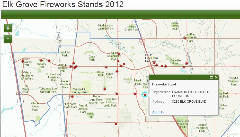
Firework Stands in Elk Grove
Searching for where to buy fireworks in Elk Grove? Check out the interactive map Interwest's GIS Team created for the City of Elk Grove using ArcGIS Online.
Click on any Fireworks Stand to view the detailed record including address and host organization.
Interwest is a proud sponsor of the 16th annual Salute to Red, White, and Blue at Elk Grove Regional Park on July 4th.
View it live at: http://interwestgis.maps.arcgis.com/apps/OnePane/basicviewer/index.html?appid=edef635e2c484dedb85ffc2be174531c
Click on any Fireworks Stand to view the detailed record including address and host organization.
Interwest is a proud sponsor of the 16th annual Salute to Red, White, and Blue at Elk Grove Regional Park on July 4th.
View it live at: http://interwestgis.maps.arcgis.com/apps/OnePane/basicviewer/index.html?appid=edef635e2c484dedb85ffc2be174531c
Thursday, June 14, 2012
Benchmark Map using ArcGIS Online
ArcGIS Online makes it simple to create an interactive online map in minutes. Check out the benchmark map we created for the City of Elk Grove.
View the live version here and click on the dots to launch detailed benchmark info.
Subscribe to:
Posts (Atom)