Showing posts with label Arc GIS Online. Show all posts

Friday, May 17, 2013

Bike Maps

In celebration of May is Bike Month, we are sharing a few of the bike maps we've worked on.  

City of Rancho Cordova Bike Trails Map


City of Elk Grove Bike Trails Map


We also created a web app for the City of Elk Grove Bike Trails that is accessible online or via phones and tablets using ArcGIS Online.  View it here.


Thursday, February 14, 2013

GIS ADA Compliance Curb Ramp Project


Interwest’s GIS Team created an ArcGIS Online application that was used in the field to collect individual curb ramp location attribute information.  The goal of the project was to create an improvement plan for the City of Bell to repair curb ramps over several fiscal years depending on priority. The plan was used to help the city with its Americans with Disabilities Act (ADA) Compliance efforts.

The GIS team met with City of Bell staff to determine a list of attributes required for the project, created a shell geodatabase with these attributes in ArcGIS Server to facilitate direct live edits into the city production data set, and brought the geodatabases together with aerial photos provided by Esri’s Bing Basemaps.  The GIS team systematically reviewed the entire city, creating a point location for each curb ramp, then created an ArcGIS Online application to be used in the field for data collection.


A field inspector visited each location and updated the condition of the curb ramps using ArcGIS Online on a 3G enabled Apple iPad.  These updates were available in real time to GIS staff at the office.

After the data collection phase was complete, the GIS team worked with project engineers to determine location priorities such as high traffic areas and physical condition of the curb ramp. After all the priorities were determined a Map Series was made to display these priorities and create an improvement plan across several fiscal years.


The data was brought into ArcMap to create maps for a public meeting to showcase the city's plans for future ramp improvements.  An ADA Transition plan was created for each fiscal year; additional maps were created to show the public the plans for the current year.


Contact us today to find out how Interwest Consulting Group's GIS Team can help your public agency use GIS in your ADA Compliance efforts.

Thursday, December 6, 2012

ArcGIS Online Presentation Slides

Steve Gay and Jason Latoski of the Interwest GIS team gave a presentation at the November Sacramento GIS User Group on several of the ways Interwest has helped clients implement ArcGIS Online.


All 4 of the presentations are available on the Sac GIS UG Blog here.

Sunday, November 11, 2012

Using GIS in Disaster Recovery

When a tornado touched down in SE Elk Grove, CA on October 22nd, Interwest Consulting Group's GIS Team at the City of Elk Grove grabbed their iPads with ArcGIS Online and headed into the field.  Working with the city's Emergency Operations Manager, Building Department and Code Enforcement Staff the team collected damage assessment data.

GIS team members surveyed the damage first hand in the field, inputting the damage location point, and updating custom fields to record the damage type and status of the clean-up efforts.  

Internal version, address removed


Using Esri's ArcGIS Online allowed the team members back at the office to receive live updates of the damage.  

The ArcGIS Online application makes it easy for team members to update the storm clean-up efforts via their phones and tablets in the field as residents begin to rebuild their fences and repair their homes and gardens.


Interested in using GIS on mobile devices in storm management and disaster recovery efforts?  Contact the GIS Team at Interwest Consulting Group to get started: http://www.interwestgrp.com/serv-gis.php 

Monday, August 20, 2012

Using GIS & Mobile Devices in ADA enhancements


This week some of our Interwest staff are in the field testing various tools to use along with ArcGISServer, ArcGIS Online and consumer grade mobile devices to conduct field inventory and assessment.  

One example is a project using an iPad to review the conditions of ADA curb ramps.  The data is captured on a device that is familiar to field staff.  The results are then immediately accessible by project managers in the office via an online map.  Field staff can even include a photo.


Need help with ADA compliance?  Contact Interwest's GIS team to discuss how we can help you fulfill your Americans with Disability Act compliance projects.

Sunday, June 24, 2012

Firework Stands in Elk Grove

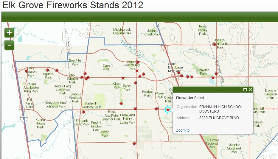
Searching for where to buy fireworks in Elk Grove?  Check out the interactive map Interwest's GIS Team created for the City of Elk Grove using ArcGIS Online.

Click on any Fireworks Stand to view the detailed record including address and host organization.

Interwest is a proud sponsor of the 16th annual Salute to Red, White, and Blue at Elk Grove Regional Park on July 4th. 

View it live at: http://interwestgis.maps.arcgis.com/apps/OnePane/basicviewer/index.html?appid=edef635e2c484dedb85ffc2be174531c


Thursday, June 14, 2012

Benchmark Map using ArcGIS Online

ArcGIS Online makes it simple to create an interactive online map in minutes.  Check out the benchmark map we created for the City of Elk Grove.

View the live version here and click on the dots to launch detailed benchmark info.