Read about how Interwest's GIS Team at the City of Rancho Cordova is using GIS to help reduce crime and costs while increasing neighborhood pride in the Fall 2013 issue of ArcNews
Monday, November 4, 2013
Monday, September 9, 2013
Interwest is Hiring GIS Analysts in our Elk Grove, CA Office
Interwest Consulting Group is hiring GIS professionals in their Elk Grove office. View the job postings on GIS Jobs Clearinghouse:
GIS Analyst
Senior GIS Analyst
Please email resume and letter of interest to careers@interwestgrp.com by September 13th.
GIS Analyst
Senior GIS Analyst
Please email resume and letter of interest to careers@interwestgrp.com by September 13th.
Tuesday, August 27, 2013
Analyzing Real Estate Statistics using GIS
Interwest’s GIS team recently began working with JohnBurns Real Estate Consulting, a consulting company that provides housing
research and consulting to builders, lenders, investors, and building product
manufacturers.
As part of their services to their housing industry
clients, John Burns Real Estate Consulting provides maps and analysis of metro area statistics throughout the United States.
Their consultants had been using Microsoft Map Point and Adobe Photoshop
to create maps, but needed a more robust system that allowed them to get the
clean look they were after without the effort involved in scrubbing the map in
Photoshop.
Interwest’s GIS team installed Esri’s ArcGIS for Desktop,
created a geodatabase with all of their geographic and demographic data, and
created a series of map templates to demonstrate building industry statistics
such as job growth, unemployment rates, affordability, resale price growth, foreclosures,
pre-forclosures, and home sales growth.
Now they are able to quickly create data driven maps that focus on the
content their clients are seeking to make housing industry decisions.
Interwest built models that will
automatically process the data from the company’s SQL database into the
geodatabase which updates existing maps with the current month’s data, saving
the consultants a lot of time each month.
Contact us today to find out how Interwest Consulting Group's GIS Team
can help your agency with your Real Estate GIS needs.
Thursday, August 1, 2013
Strengthening Pavement Management Planning with GIS
A Pavement Management Program (PMP) provides a public agency with the maintenance history, current pavement condition index (PCI) and a plan for the future update of the public streets it maintains. Agencies perform maintenance on streets each year as funds are available.
Interwest works with our public agency clients to strengthen their PMP programs using GIS and pavement management software. Interwest has experience implementing the Metropolitan Transportation Commision's StreetSaver PMP for several clients including The City of Eastvale, The City of Bell, and the City of Wildomar. The GIS component is an integral part of the PMP.
Benefits:
- Direct visual display and connection with the data showing existing or future conditions of pavements
- A planning tool for staff and management in planning projects in their City.
- Exhibits and maps for Engineering and construction contract bid documents, public outreach information, and/or for presentation to Council.
- Provides supportive documents for securing grant funds
- Develop a list of pavement areas recommended for maintenance and analyze the impact of various budget scenarios.
Using Esri’s ArcGIS for Desktop, the GIS team created various maps showing the pavement condition of all of the streets and which streets would be upgraded in each fiscal year for the next 5 years. The ability to see pavement condition and future projects on a map display is a great help for project engineers
Interwest Can:
- Acquire street data from counties, council of governments, or other local sources
- Track road conditions from the field on tablets, phones, and other mobile devices
- Analyze pavement condition ratings and degradation over time, so agencies can make plans over the next 5 years regarding which roads need maintenance
- Create a plan for budgeting the repairs and tracking the type of road rehabilitation that is needed allowing the agencies to coordinate repairs geographically to save time servicing one geographic region at a time
- Create various maps showing the pavement condition of all of the streets and which streets would be upgraded in each fiscal year.
Contact us today to find out how Interwest Consulting Group's GIS Team can help your public agency strengthen your Pavement Management Program with GIS.
Friday, May 17, 2013
Bike Maps
In celebration of May is Bike Month, we are sharing a few of the bike maps we've worked on.
City of Rancho Cordova Bike Trails Map
City of Elk Grove Bike Trails Map
We also created a web app for the City of Elk Grove Bike Trails that is accessible online or via phones and tablets using ArcGIS Online. View it here.
Thursday, May 16, 2013
Relational Editing using Attribute Assistant in ArcGIS Desktop
Ronnie Richards of the Interwest GIS team gave a presentation at the May Sacramento GIS User Group on using relational editing using attribute assistant in ArcGIS Desktop.
You can view the presentation online here.
Wednesday, May 15, 2013
NGIS Conference - May 15 - 17th
Find us at the NGIS Conference. GIS Manager Mark Dumford and GIS Consultant Bob Earle are attending the conference in Reno this week.
Tuesday, May 14, 2013
Sacramento GIS User Group Today
Interwest Consulting Group is hosting and Senior GIS Analyst Ronnie Richards is speaking at the Sacramento GIS User Group today. Join us at the Water Resources Building lobby auditorium.
Sacramento Area GIS User Group Meeting – May 14th, 2013
Lobby auditorium of the Resources Building
1416 9th Street (9th and N).
Sacramento CA
1416 9th Street (9th and N).
Sacramento CA
Agenda:
9:00 AM: Welcome
9:10 AM: Ruppert Grauberger, Department of Water Resources, Chief, Mapping and Photogrammetry Section -- "DWR’s Aerial Photography Indexing System"
9:40 AM: Ronnie Richards, Senior GIS Analyst, Interwest Consulting Group -- "Relational Editing using Attribute Assistant in ArcGIS Desktop"
10:10 AM: Break & Refreshments (Courtesy of Interwest Consulting Group)
10:30 AM – Noon: GIS Educational Resources – short program presentations and Roundtable discussion of GIS programs in the area. Audience participation is encouraged.
· Dr. Hugh Howard, Professor, GIS and Geography, American River College
· Dr. Jason Pittman, Professor, GIS and Geography, Folsom Lake College
· Magy Hoyer, Program Assistant, and Julia Lave Johnston, Director, Land Use and Natural Resources, UC Davis Extension
· Rod Brown, Sierra College
· Seth Hiatt, Associate Director, Institute for Geographic Information Science, San Francisco State University
Our Website: http://sacramentogis.blogspot.com/
Sunday, April 14, 2013
CalGIS 19th Annual California Conference - April 15 - 17th
Interwest is a proud sponsor of the CalGIS Conference this week in Long Beach. GIS Manager Steve Gay and GIS Analyst Brad Findlay are attending and hope to see you there!
Ronnie Richards presenting at the Sacramento GIS User Group May 14th 9am - 12pm
Senior GIS Analyst Ronnie Richards is presenting at the Sacramento GIS User Group on May 14th.
He will be discussing Relational Editing using Attribute Assistant in ArcGIS Desktop.
More details about the User Group can be found here.
He will be discussing Relational Editing using Attribute Assistant in ArcGIS Desktop.
More details about the User Group can be found here.
Thursday, April 4, 2013
URISA News
Interwest is proud to announce GIS Analyst Jason Latoski has been elected to the Northern California URISA Board. Congratulations Jason!
Interwest will be at the URISA Cal GIS Conference April 15 - 17 in Long Beach. Hope to see you there!
Interwest will be at the URISA Cal GIS Conference April 15 - 17 in Long Beach. Hope to see you there!
Thursday, February 14, 2013
GIS ADA Compliance Curb Ramp Project
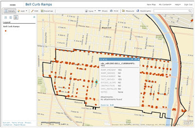
 Interwest’s GIS Team created an ArcGIS Online application that was used in the field to collect individual curb ramp location attribute information. The goal of the project was to create an improvement plan for the City of Bell to repair curb ramps over several fiscal years depending on priority. The plan was used to help the city with its Americans with Disabilities Act (ADA) Compliance efforts.
The GIS team met with City of Bell staff to determine a list of attributes required for the project, created a shell geodatabase with these attributes in ArcGIS Server to facilitate direct live edits into the city production data set, and brought the geodatabases together with aerial photos provided by Esri’s Bing Basemaps. The GIS team systematically reviewed the entire city, creating a point location for each curb ramp, then created an ArcGIS Online application to be used in the field for data collection.

A field inspector visited each location and updated the condition of the curb ramps using ArcGIS Online on a 3G enabled Apple iPad. These updates were available in real time to GIS staff at the office.
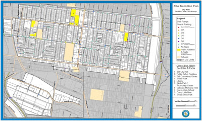
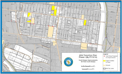
 After the data collection phase was complete, the GIS team worked with project engineers to determine location priorities such as high traffic areas and physical condition of the curb ramp. After all the priorities were determined a Map Series was made to display these priorities and create an improvement plan across several fiscal years.
The data was brought into ArcMap to create maps for a public meeting to showcase the city's plans for future ramp improvements. An ADA Transition plan was created for each fiscal year; additional maps were created to show the public the plans for the current year.
Contact us today to find out how Interwest Consulting Group's GIS Team can help your public agency use GIS in your ADA Compliance efforts.
Labels:
ADA,
ADA Compliance,
Arc GIS Online,
Collector,
GIS ADA Compliance,
GIS iPads,
GIS Mobile Devices,
livable communities,
smart community
Subscribe to:
Posts (Atom)


