Thursday, October 18, 2012

Using GIS to Map Transit Routes on Mobile Phones

Check out the easy to use bus system at the City Elk Grove right from your cell phone or mobile device.

Interwest's GIS Team at the City of Elk Grove helped compile and process the bus routes and
stops, provided it to SacRT and they loaded it into a Google transit service.

To use it, click on Google Maps just as you would to get driving directions.  Then click the icon with the "bus". 
 
The transit will tell you the first stop and tell you to walk there.

Then after you take the bus it will tell you to walk to your final destination.


Need some help updating your transit routes for mobile devices?  Contact the GIS Team at Interwest Consulting Group to get started: http://www.interwestgrp.com/serv-gis.php 

Friday, September 7, 2012

GIS Property Viewer at City of Lodi Now Live

Interwest Consulting Group's GIS Team created both the internal and external GIS Property Viewer for the City of Lodi's GIS Department using Latitude GeographicsGeocortex software, Esri's ArcGIS Server, and Microsoft's Silverlight.

View the public site for citizens live at: http://maps.lodi.gov/maps/?Viewer=Property


When the City of Lodi outgrew the capabilities of their existing Map Guide software, Interwest was selected to convert the city's data into an Esri geodatabase containing over 120 layers.  The data provides city staff with water, wastewater, storm drain, and other detailed infrastructure information.  The public viewer provides citizens with access to a wide range of information including zoning, land use, and bus routes.

The GIS viewer tool allows staff to quickly research property information, produce reports, and develop easy to use maps.  Citizens can access information 24 hours a day without having to visit City Hall saving the city both time and money.


Interwest's GIS team has experience implementing and designing GIS Viewers for many of our clients.  Contact us to discuss how we can find the right GIS Viewer Solution for you.

Monday, August 20, 2012

Using GIS & Mobile Devices in ADA enhancements


This week some of our Interwest staff are in the field testing various tools to use along with ArcGISServer, ArcGIS Online and consumer grade mobile devices to conduct field inventory and assessment.  

One example is a project using an iPad to review the conditions of ADA curb ramps.  The data is captured on a device that is familiar to field staff.  The results are then immediately accessible by project managers in the office via an online map.  Field staff can even include a photo.


Need help with ADA compliance?  Contact Interwest's GIS team to discuss how we can help you fulfill your Americans with Disability Act compliance projects.

Tuesday, July 24, 2012

Join us tonight at the ESRI UC - 5:30pm on the West Terrace


Are you at ESRI's User Conference in San Diego this week?  

Interwest is sponsoring the CA/HI/NV Regional User Group Reception at 5:30 tonight, Tuesday July 24.  Meet us on the West Terrance for good food, drinks and conversation.  

Thursday, July 19, 2012

Building Permit Maps for City Council Reports

Each month the City of Elk Grove develops a report for city council that describes the building permit activity for that month.  Interwest GIS staff in the City's GIS department uses Esri's ArcGIS Desktop to produce a map and chart that is part of the report.  The city's building department provides the permit data from the permit system in a spreadsheet.  This data is geocoded for plotting on the map.  Each months total permit count is summarized and added to a rolling 12 month graph.  The map and chart includes data for both residential and commercial permits.

View a pdf of last month's map on the City's website.


Interwest provides GIS services for local government agencies throughout California.  If you need help with a GIS project, give us a call or meet up with us at the ESRI User conference in San Diego next week.

Interwest will be sponsoring the CA/HI/NV Regional User Group Reception at 
5:30 on Tuesday July 24.  
Meet us on the West Terrance for good food, drinks and conversation.  

See the link below to add the event to your online conference agenda:

Sunday, June 24, 2012

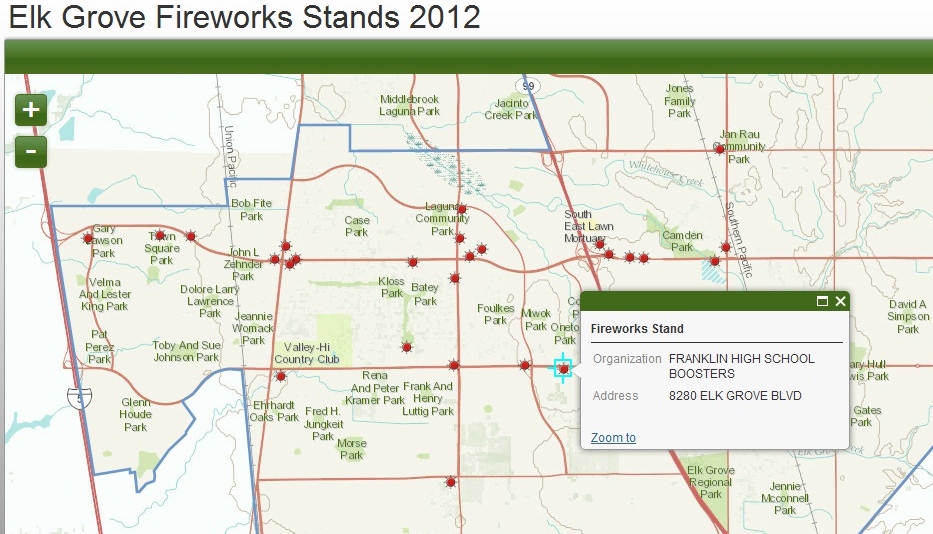
Firework Stands in Elk Grove

Searching for where to buy fireworks in Elk Grove?  Check out the interactive map Interwest's GIS Team created for the City of Elk Grove using ArcGIS Online.

Click on any Fireworks Stand to view the detailed record including address and host organization.

Interwest is a proud sponsor of the 16th annual Salute to Red, White, and Blue at Elk Grove Regional Park on July 4th. 

View it live at: http://interwestgis.maps.arcgis.com/apps/OnePane/basicviewer/index.html?appid=edef635e2c484dedb85ffc2be174531c