Showing posts with label Web AppBuilder. Show all posts

Monday, January 30, 2017

Mailing Labels for Owners, Occupants and Neighborhood Groups

The City of Berkeley was in need of a mailing label application that could export lists of addresses based on a buffer around a parcel, point, or line.

The City required mailing labels for the following: 

1. Owners: A query layer was used to combine the two parcel layers into one Owners layer: one for parcels inside the city and one for parcels within a half mile of the city boundary.

2. Occupants: A query layer was used to join the point layer of occupants with the parcel layer to create one parcel layer allowing all occupants of a single parcel to be selected when the parcel is selected.

3. Neighborhood Groups

Interwest utilized Esri's Web AppBuilder to create the application in the City's ArcGIS Online Account.

The users can search for the APN, Situs Address, or Neighborhood Group name.


The search locates and selects the parcel:


The Situation Awareness widget was utilized to provide the buffer and export. Initial the buffer, input the # of feet to buffer around the parcel and the buffer will draw on the map.
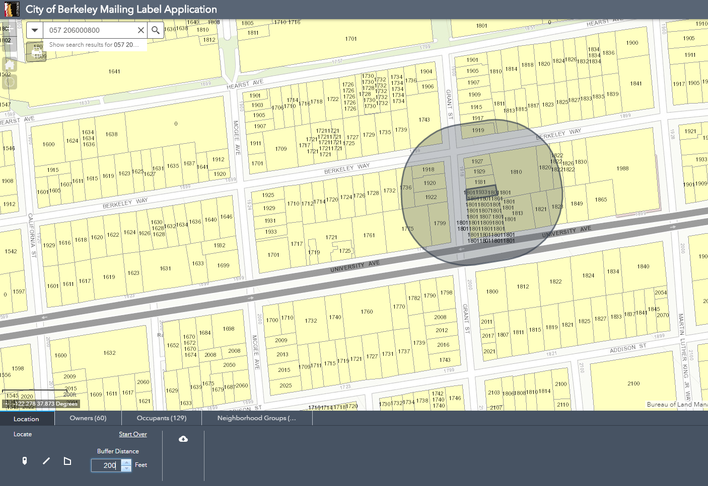

Click the Owner, Occupants, or Neighborhood Groups tabs to view the selected parcels and download the csv file.


The tool can also be used to drop a point, draw a line, or draw a polygon to select the owners, occupants, and neighborhood groups. 


Need assistance creating a mailing label application for your agency? Connect with us at: http://www.interwestgrp.com/serv-gis.php 

Tuesday, January 10, 2017

Location Analysis

With the passing of Proposition 64, many cities need to provide their council and citizens with information on where they could potentially open a marijuana dispensary.

City of Ukiah staff needed to provide their city council with options on where dispensaries could be located that would meet the location requirements including:

  • 600ft distance from schools
  • Distance from youth facilities (250ft or 500ft) 
  • Zoning 
In addition to the static maps for City Council, an interactive web app was created using Esri's web app builder. The web app allows the planning committee to review the locations, owners, and see summaries at two different distances from youth facilities.


Need help with a GIS location project? Connect with us at: http://www.interwestgrp.com/serv-gis.php 

Thursday, November 10, 2016

Using GIS for Transit Analysis

Interwest provides GIS services to public agencies to analyze route changes and ridership. The City of Elk Grove is conducting a Comprehensive Transit Analysis that will be used to define the future of transit in the City.

Interwest GIS created an interactive web application using Esri's Web AppBuilder to show existing and proposed routes. As part of the analysis, the City's transit team developed a "service plan working paper" that included exhibits showing the recommended service improvements. This web app displays the information in an interactive form that allows the public and council members to review the proposals with more flexibility.

The web map also needed to display the relationship between routes and major employment centers, schools, and hospitals.


Interwest GIS worked with IBI, the City's Transit Consultant, to convert the proposed routes from Adobe Illustrator exhibits into a format that could be published to an ArcGIS Online web map. Special attention was placed on the zoom scale of the application to support the visual requirements of offsetting routes to display multiple features while ensuring it wasn't possible to zoom in far enough for the routes to appear not on the roadway.