Thursday, September 22, 2016

Croudsource Storymap GIS Game

We had a work retreat last weekend in Monterey, CA. 90 families from our Northern California offices gathered for a fun weekend. Terry, the president of our company, suggested our GIS team make a game for the retreat. (yes, actually, we are hiring ;)

Premise of the Game:
Earn points for sharing photos of your trip via a web app accessible on a smart phone


Our team created 5 different applications and tested them out in the field. The options we evaluated included:

  • WebApp Builder 
  • Public Info AGO Template
  • Find, Edit, Filer AGO Template
  • Citizen Report Web App
  • Crowdsource Storymap

We settled on the Crowdsource Storymap, key reasons included:
  • Intuitive, easy to use
  • ability to login from facebook, google, or ArcGIS Online
  • Gallery feature to easily view other employees' photos


Game Logistics:

  1. Point layer of 15 destinations at the Asilomar Conference Grounds and around Monterey 
  2. A second point layer with 3 hidden destinations
  3. A leaderboard webpage to display
    1. The top 10 point earners
    2. Clues for the 3 hidden stops
    3. Once someone found a hidden stop, display the username and date/time it was found 
    4. Link to launch the game
  4. Employees were set loose with their phones and a link to the leaderboard  
  5. A script ran every 15 minutes to download the crowdsource layer from ArcGIS Online to our SQL Server, give points based on proximity to the 15 destinations or 3 hidden destinations, verify the user did not already get a point for this location, and update a table with each users' point total. 

At the end of the game, we downloaded the photos and shared them at a slideshow during the Saturday evening dinner where the top three point earners won prizes. An extra prize was added for the funniest selfie with Terry!

Our Southern California offices are gathering for a retreat in one week in San Diego. We are working on a new dataset for their retreat and a fun new point scheme!

Check out the Crowdsource Storymap and let us know if we can help create a game for your next team building event! 


Tuesday, May 31, 2016

Using GIS to achieve ADA Title II Self Evaluation & Transition Plan Compliance

Interwest provides GIS services to public agencies to assist with the Americans with Disabilities Act’s (ADA) Title II Self Evaluation and Transition Plan requirements for agencies with 50 or more employees. The goal of this project was to perform a self evaluation of the City of Ceres’ programs, services, and public right-of-way and develop a transition plan for the City to ensure compliance with the ADA.  

ROLE OF GIS


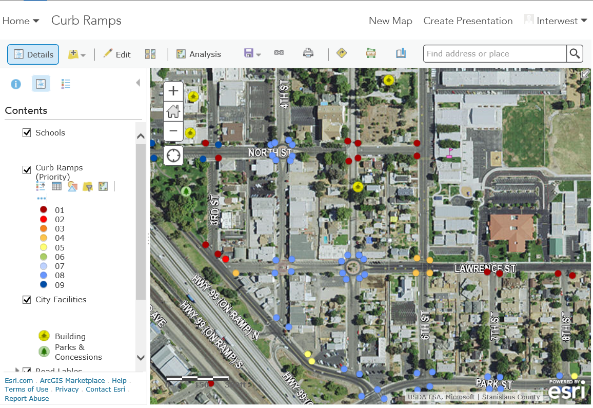
GIS created a tool to assist the City of Ceres in automating the collection and monitoring of facilities and curb ramps.

DATA CREATION

The GIS Team acquired data from Stanislaus County, used existing City data and digitized new data needed to develop basemaps and for running the ranking analysis on the ramps. Our team created a data model to capture physical attributes and images of the ramps, published the data to the City’s ArcGIS Online account, and created web maps to be used for curb ramp collection in Collector for ArcGIS. 

Interwest GIS worked with the City to develop ranking criteria based on location and physical properties identified during collection to assist in mapping the curb ramps by priority. 


FIELD ASSESSMENT

Interwest provided a team of two field personnel who collected images and attributes in Collector on iPad minis. The assessment was completed in three weeks. 

After the field inspection phase was complete, the GIS team worked with engineers implement the ranking criteria. For example, ramps in high traffic locations with excessive slopes or concrete displacement would receive a high priority rank.


MONITORING AND PLANNING 

After all the rankings were determined, Interwest GIS created an overall city map displaying the curb ramps ranking and published it to the City’s ArcGIS Online account for viewing by City staff. 

City staff can use the data and map to monitor, plan, and track improvement of the curb ramps withing the City. 


Need help developing your agency's ADA self evaluation and transition plan? Contact Interwest's GIS Team for more details! 

Thursday, May 26, 2016

Historic Sites Story Map

Interwest's GIS Team recently created an Historic Sites Story Map for the City of Ukiah to highlight images, history and provide a spatial reference for citizens and tourists to visit the sites.


Story maps are a great way to showcase your agency's assets. Story maps can also be turned into mobile applications using AppStudio to give wider access to public art, historic sites, and tourist attractions.

Need help telling your city's story with a Story Map? Contact Interwest's GIS Team to learn more.

Friday, May 20, 2016

Interwest is Hiring!

Interwest is hiring!

GIS Analyst and GIS Technician's check out our openings in Sacramento:


Thursday, May 19, 2016

Workforce for ArcGIS Presentation at Sacramento GIS User Group

Yesterday, Carlos Porras gave a presentation at the Sacramento GIS User Group meeting featuring Workforce for ArcGIS


CalGIS 2016 Presentations

Interwest was honored to have two presentations at CalGIS in Anaheim last week. If you missed the conference, you can view the slides at: 

GIS Integration with StreetSaver Pavement Management, Mark Dumford and Brad Findlay

3D Spatial Analysis for Local Governments, Mary Ellen Rosebrough, GISP


Monday, April 25, 2016

CalGIS Conference May 10 - 12th


Several members of Interwest's GIS Team will be attending the CalGIS Conference in Anaheim, CA.

May 10 - 12th.

Please stop by Booth #302 to meet our team.


And check out our sessions:

Thurs, May 12 at 1:55 - 2:15pm
3D Spatial Analysis for Local Governments, Mary Ellen Rosebrough, GISP

Thurs, May 12 at 2:45 - 3:05pm 
GIS Integration with StreetSaver Pavement Management, Mark Dumford and Brad Findlay